Sensor Dump Virtual Annotation Dataset
1. Overview
The 51WORLD virtual annotation dataset primarily contains camera sensor data and LiDAR sensor data generated by SimOne.
- Camera sensor data mainly includes images and corresponding semantic segmentation, instance segmentation, depth annotations, and object detection annotations.
- LiDAR sensor data mainly includes point cloud data and corresponding 3D bounding box annotations, semantic segmentation annotations, and instance segmentation annotations.
The 51WORLD virtual annotation dataset is rich and comprehensive, meeting users' research needs for image object detection, point cloud object detection, fusion object detection, optical flow, instance segmentation, semantic segmentation, and depth prediction algorithms.
To help users quickly understand and use the 51WORLD virtual annotation dataset, the following five sections describe how to work with it.
Section 2 describes the coordinate system definitions and the relationships among the coordinate systems in the dataset.
Section 3 describes the dataset's parameter configurations and annotation files.
Section 4 describes the dataset's directory structure.
Section 5 describes dataset synchronization.
Section 6 is an appendix covering the dataset's physical material definitions, user tools, and deep learning examples.
2. Dataset Coordinate System Definitions
All coordinate systems are right-handed Cartesian coordinate systems. The rotation order is intrinsic ZYX (Yaw, Pitch, Roll). The Ego Vehicle coordinate system, LiDAR coordinate system, and world coordinate system have X pointing forward, Y pointing left, and Z pointing up. The camera coordinate system has X pointing right, Y pointing down, and Z pointing forward. The coordinate system diagram is shown below.
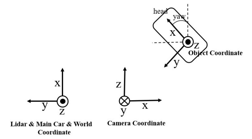
Figure 2-1: Coordinate System Diagram
The origins of the LiDAR and camera coordinate systems are both located at the top of the Ego Vehicle and coincide in position. The origin of the Ego Vehicle coordinate system is located on the ground directly below the rear axle center. The diagram is shown below:
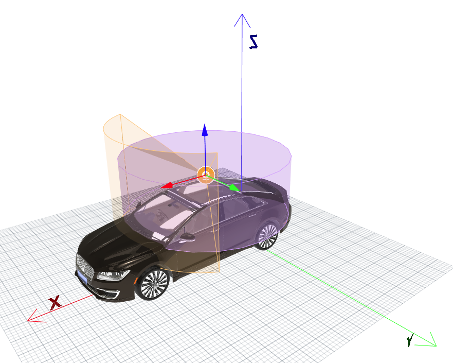
Figure 2-2: Coordinate System Position Diagram
3. Dataset Parameters and Annotation File Descriptions
3.1 Dataset Collection Parameters
A dataset parameter file is saved as DumpSettings.json each time a virtual dataset is collected. It is stored in the sensor Dump settings directory under the Dump folder and includes weather and environment parameters, camera intrinsic/extrinsic parameters and characteristics, LiDAR intrinsic/extrinsic parameters, collection time, and other information. The dataset collection parameters are described in the table below.
Table 3-1: DumpSettings.json Parameter Descriptions
| Parameter Field | Unit | Description |
|---|---|---|
| simulator | \ | Simulator name. This dataset is generated by SimOne. |
| version | \ | SimOne version number. |
| weather | timeOfDay uses 24-hour format; e.g., 900 = 9:00, 1450 = 14:30. cloudDensity, rainDensity, snowDensity, fogDensity, humidity, dirtiness, adhesion are all continuous values in the range 0–1; higher values indicate greater intensity. | Weather and time parameters, including: timeOfDay (scene time), cloudDensity, rainDensity, snowDensity, fogDensity, humidity (road surface moisture), dirtiness (road surface dirt), adhesion (road surface friction). |
| camera | pos unit: m; rot unit: rad. | Camera intrinsic and extrinsic parameters. pos and rot represent the camera's position and rotation relative to the Ego Vehicle coordinate system; height and width are the image dimensions; fov is the camera's horizontal field of view; cx, cy, fx, fy are the camera calibration intrinsic parameters; exposure, tint, saturation, and other parameters simulate camera characteristics such as exposure, color temperature, and saturation. |
| lidar | pos unit: m; rot unit: rad; range unit: m; horizontalResolution, leftAngle, rightAngle, verticalAngles unit: degrees. | LiDAR intrinsic and extrinsic parameters. pos and rot represent the LiDAR's position and rotation relative to the Ego Vehicle coordinate system; channels is the number of LiDAR lines; horizontalResolution is the horizontal resolution; leftAngle and rightAngle define the sensing range; verticalAngles lists the emission angles for each LiDAR beam; range is the detection distance. |
| createTime | Machine time. | Records the time at which this dataset was created. |
3.2 Camera Object Annotation File Description
Camera object annotation files are stored as CameraInfo.json in the Dump folder at the configured camera path. These files save camera position information and 2D/3D annotation information for detected objects. The camera object annotation file parameters are described below.
Table 3-2: Per-Frame Record Parameter Information
| Reference Field | Unit | Description |
|---|---|---|
| pos | m | Camera position in the world coordinate system (x, y, z) |
| rot | rad | Camera rotation in the world coordinate system |
| vel | m/s | Camera velocity in the world coordinate system |
| localACC | m/s² | IMU acceleration in the Ego Vehicle coordinate system |
| localAngVel | rad/s | IMU angular velocity in the Ego Vehicle coordinate system |
| bboxes | \ | Collection of 2D bounding boxes for all objects below the occlusion ratio threshold |
| bboxesCulled | \ | Collection of 2D bounding boxes for all objects above the occlusion ratio threshold |
| bboxes3D | \ | Collection of 3D bounding boxes for all objects |
Table 3-3: Per-Object Parameters for bboxes and bboxesCulled
| Reference Field | Unit | Description |
|---|---|---|
| id | \ | Object ID |
| type | \ | Object type |
| bbox | pixel | Object coordinates in the image coordinate system (upper-left x and y, lower-right x and y) |
| obbox | pixel | Oriented coordinates of the object in the image coordinate system (center, width, height, angle) |
| pixelRate | ratio, range 0–1 | Unoccluded pixel area / total BBOX rectangle area of the model |
| rectRate | ratio, range 0–1 | Minimum bounding rectangle area of unoccluded pixels / total BBOX rectangle area of the model |
Table 3-4: Per-Object Parameters for bboxes3D
| Reference Field | Unit | Description |
|---|---|---|
| id | \ | Object ID |
| type | \ | Object type |
| pos | m | Object position in the world coordinate system |
| rot | rad | Object rotation in the world coordinate system |
| size | m | Object dimensions (length, width, height) in the world coordinate system |
| vel | m/s | Object velocity in the world coordinate system |
| localAcc | m/s² | IMU acceleration of the object in the Ego Vehicle coordinate system |
| localAngVel | rad/s | IMU angular velocity of the object in the Ego Vehicle coordinate system |
| relativePos | m | Object position relative to the camera coordinate system |
| relativeRot | rad | Object rotation relative to the camera coordinate system |
3.3 LiDAR Object Annotation File Description
LiDAR object annotation files are stored as LidarInfo.json in the Dump folder at the configured LiDAR path. These files save LiDAR pose information and 3D annotation information. The LiDAR object annotation file parameters are described below.
Table 3-5: Per-Frame Record Parameter Information
| Reference Field | Unit | Description |
|---|---|---|
| pos | m | LiDAR position in the world coordinate system (x, y, z) |
| rot | rad | LiDAR rotation in the world coordinate system |
| vel | m/s | LiDAR velocity in the world coordinate system |
| localAcc | m/s² | IMU acceleration in the Ego Vehicle coordinate system |
| localAngVel | rad/s | IMU angular velocity in the Ego Vehicle coordinate system |
| bboxes3D | Collection of 3D bounding boxes for all objects |
Table 3-6: Per-Object Parameters for bboxes3D
| Reference Field | Unit | Description |
|---|---|---|
| id | \ | Object ID |
| type | \ | Semantic type of the object |
| pos | m | Object position in the world coordinate system |
| rot | rad | Object rotation in the world coordinate system |
| size | m | Object dimensions (length, width, height) in the world coordinate system |
| vel | m/s | Object velocity in the world coordinate system |
| localAcc | m/s² | IMU acceleration of the object in the Ego Vehicle coordinate system |
| localAngVel | rad/s | IMU angular velocity of the object in the Ego Vehicle coordinate system |
| relativePos | m | Object position relative to the LiDAR coordinate system |
| relativeRot | rad | Object rotation relative to the LiDAR coordinate system |
3.4 Millimeter-Wave Radar Object Annotation File Description
Millimeter-wave radar Dump files are stored as RadarInfo.json in the Dump folder at the path configured in the web interface. These files save the radar's installation position and angle information, as well as detected object information. The specific Dump file fields are described below.
Table 3-7: Per-Frame Record Parameter Information
| Reference Field | Unit | Description |
|---|---|---|
| pos | m | Millimeter-wave radar position in the world coordinate system (x, y, z) |
| rot | rad | Millimeter-wave radar rotation in the world coordinate system |
Table 3-8: Per-Object Parameters for bboxes3D
| Reference Field | Unit | Description |
|---|---|---|
| id | \ | Object ID |
| subId | \ | Object sub-ID. If the same object has multiple points, their subId values differ. |
| type | \ | Object type |
| pos | m | Object position (x, y, z) |
| vel | m/s | Object absolute velocity (x, y, z) |
| range | m | Relative distance to the object |
| angle | 0–2π | Object angle (angle between the object and the Ego Vehicle heading) |
| snr | dB | Object signal-to-noise ratio |
| rangerate | m/s | Relative velocity of the object with respect to the Ego Vehicle along the Ego Vehicle heading |
| rsc | \ | Radar cross-section of the object |
| probability | 0–1 | Object confidence score |
4. Dataset Directory Structure Description
The 51WORLD virtual annotation dataset contains a wide variety of data, meeting users' research needs for image object detection, point cloud object detection, fusion object detection, optical flow, instance segmentation, semantic segmentation, and depth prediction algorithms. The overall dataset directory structure is as follows. Users can also download specific dataset components based on their requirements.
    SimOne
        |--- train
            |--- scene1
                |---image_label
                |---pcd_label
                |---pcd_bin
                |---image
                |---image_segmentation
                |---depth
                |---image_instance
                |---flow_flagbit_forward
                |---flow_groundtruth_forward
                |---flow_flagbit
                |---flow_groundtruth
                |---flow_panoptic
                |---video
                |---DumpSettings.json
            |--- scene2
            ...
        |--- test
            |---scene1
                |---pcd_bin
                |---image
                |---video
                |---DumpSettings.json
            |--- scene2
            ...
The descriptions for each directory and file are as follows.
Table 4-1: Folder and File Descriptions
| Filename / Folder Name | Description |
|---|---|
| scene | Used to record the data release time or scene information |
| image_label | Stores image object annotation files |
| pcd_label | Stores point cloud object annotation labels |
| pcd_bin | Stores binary point cloud data, including x, y, z, and intensity |
| image | Stores simulated image data |
| Image_segmentation | Stores image semantic segmentation data; pixel values 1–31 each represent one category |
| depth | Stores depth maps |
| image_instance | Stores image instance segmentation maps; each color represents one class |
| flow_panoptic | Stores panoptic segmentation images; categories are distinguished by color |
| video | Stores video and labels; labels correspond to video frames by timestamp |
| DumpSettings.json | Stores dataset configuration parameters at the time of download, such as camera intrinsic/extrinsic parameters |
5. Dataset Synchronization
The sensor dataset uses offline synchronization. When sensors output data at the same or multiple frame rates, all sensor outputs are strictly time-synchronized. In the 51WORLD virtual annotation dataset, every type of data is fully synchronized — precise to each vehicle's position and heading and each pedestrian's pose and action. Using SimOne's sensor dataset synchronization mechanism, camera and LiDAR data can also be fully synchronized, as demonstrated in the LiDAR simulation output shown earlier. Based on fully synchronized camera and LiDAR datasets, it is easier to test and train perception fusion algorithms.
6. Appendix
6.1 User Tools
To help users work with the dataset, we provide two tools: a data loading tool and a KITTI conversion tool. See the user_tools folder for details.
6.2 Physical Materials
This dataset annotates 31 physical materials covering dynamic and static obstacles, buildings, and environmental elements. The physical materials and their corresponding IDs and RGB colors are listed in the table below.
Table 6-1: 51WORLD Dataset Physical Materials
| type | Physical Material | Assets | RGB |
|---|---|---|---|
| 1 | Foliage | Trees, shrubs, relatively tall flowers | 107,142,35 |
| 2 | Building | Various types of buildings | 70,70,70 |
| 3 | Road | Driving lanes | 128,64,128 |
| 4 | Pedestrian | Pedestrians and small items on pedestrians (e.g., phones, backpacks, suitcases) | 220,20,60 |
| 5 | Pole | Traffic sign or traffic light poles, streetlights with poles, other ground-level poles | 153,153,153 |
| 6 | Car | Passenger cars | 0,0,142 |
| 7 | Static | Unclassified static objects: roadside bus stops, phone booths, etc. | 0,0,0 |
| 8 | Bicycle | Dynamic bicycles on the road | 119,11,32 |
| 9 | Fence | Fences, building enclosures | 190,153,153 |
| 10 | Sky | Sky | 70,130,180 |
| 11 | SideWalk | Sidewalks | 244,35,232 |
| 12 | RoadMark | Lane markings | 240,240,240 |
| 13 | TrafficSign | Traffic signs, directional signs | 220,220,0 |
| 14 | Wall | Boundary walls | 102,102,156 |
| 15 | TrafficLight | Traffic lights | 250,170,30 |
| 16 | Terrain | Grass, sand, dirt, roadside flower bed ground, low flowers in flower beds | 152,251,152 |
| 17 | Rider | People on bicycles, people on motorcycles | 255,0,0 |
| 18 | Truck | Trucks, concrete mixers, box trucks | 0,0,70 |
| 19 | Bus | Coaches, buses | 0,60,100 |
| 20 | SpecialVehicle | Special vehicles: police cars, ambulances, fire trucks, trains, light rail | 0,80,100 |
| 21 | Motorcycle | Motorcycles, electric scooters | 0,0,230 |
| 22 | Dynamic | Unclassified dynamic objects (e.g., small animals); also used for movable objects such as temporary roadside furniture, pedestrians' suitcases, strollers | 111,74,0 |
| 23 | GuardRail | Traffic barriers | 180,165,180 |
| 24 | Ground | Other flat ground, water surfaces | 81,0,81 |
| 25 | Bridge | Bridges, overpasses, pedestrian bridges | 150,100,100 |
| 26 | SpeedLimitSign | Speed limit signs | 220,220,0 |
| 27 | StaticBicycle | Static bicycles on the roadside | 169,11,32 |
| 28 | Parking | Parking lots, roadside parking areas | 250,170,160 |
| 29 | RoadObstacle | Static obstacles on the road: traffic cones, water barriers, pylons, dividers, etc. | 230,150,140 |
| 30 | Tunnel | Tunnels | 150,120,90 |
| 31 | TrashCan | Trash cans | 151,124,0 |
6.3 Download Link
Baidu Netdisk: https://pan.baidu.com/s/1FDeb3mcY8J79A6o6IydKOQ
Extraction code: 5151
6.4 Algorithm Examples
This dataset includes three simple algorithm examples: an image object detection algorithm, a LiDAR object detection algorithm, and a fusion object detection algorithm. The image object detection algorithm is an unofficial implementation of YOLOv2; the LiDAR object detection algorithm is an unofficial implementation of PIXOR; and the fusion object detection algorithm is the MVX-NET algorithm from the mmdetection3d framework. Users can select an algorithm example to develop and optimize based on their requirements. For details, see:
- Image object detection algorithm: https://github.com/JaHorL/yolov2-51WORLDDataset
- LiDAR object detection algorithm: https://github.com/JaHorL/pixor-51WORLDDataset
- Fusion object detection algorithm and LiDAR object detection algorithm (mmdetection3d): https://github.com/JaHorL/mmdet3d-51WORLDDataset